Today we are going to be learn digitizing and a little image processing. Digitzing
is getting digital versions of any existing analog data. You are probably very
familiar with scanning which is digitizing picture as a raster image. What we
are going to work on today is digitizing lines or pictures into a vector form
on the computer---remember the difference between raster and vector from the beginning
of the term?
There are two basic ways to digitize into vectors:
1) Heads-up digitizing where you scan a picture in and then trace over it on
screen. You have done this within Arcview.
2) Digitizing using a digitizing tablet. We will digitize both ways in this
exercise using the macs in the Geology Department's computer lab.
The Geology Department's digitizing tablet is attached to a Mac in the computer
lab. To use it, you have to be familiar with a Mac. Likewise the heads
up digitizing program, NIH Image, runs on the mac.
If you want export any information digitized from these programs, you have
to be able to get files from that Mac to your H: drive.
This file will be stored on the desktop of that MacIntosh for you to use/see
while you're working.
- Using the digitizing tablet
- Doing Heads-up digitizing with NIH Image
- Transfering files via the Netware Login
- Your homework assignment
Using the Digitizer
- turn on the mac
- find the "Digitize" alias on the desktop
...or under the Apple Menu, choose "Recent Applications"
...or under the File Menu go to "Find" and then type "Digitize"
- From the Conifigure menu choose Setup
Tablet
this gets the digitizer to stop behaving like a big mouse pad
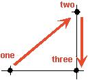
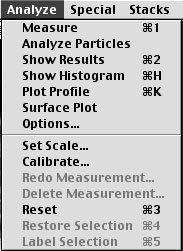
- Again from the Configure Menu, choose Calibrate
this gives you a screen that looks like this
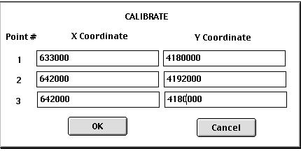
These points must be on two perpendicular axes that define x and
y coordinate space, type in the appropriate values (tab moves you from box to
box) and after you press ok, they must be digitized in this order
The program then asks you for the working area of the tablet. Click first
in the lower left then upper right sides of a box than contains the area in
which you're going to work. That box is what will be displayed on the
screen, although you can still digitize points outside the visible area.
- THE FIRST THING YOU NEED TO DO IS CHECK THE CALIBRATION !
put the puck on an x then a y that was not part of the cailibration, to see
if you've got it correct.
- To digitize points, simply click on them
- To digitize lines or polygons, choose the appropriate begin and end command
from the mode menu.
Saving the file It takes two steps to make a useable file out of a digitizer
file.
-
Click on the text box (or bring it forward using the menu) and choose save
(making sure that you put it in a known and reasonable place...don't just
clutter up the desktop. There is a folder under the G3 icon called
aadigitize files, where you can TEMPORARILY store your files). This
saves the file in "digiitzer" format.
-
You can then REFORMAT the file using the REFORMAT menu. Here you
will either make a CAD file out of it (DXF format, which can be read by
a GIS) or a tab-delimited text file (which can also be read by a GIS or
spreadsheet)
Things to watch out for
-
decimal places (don't over or under do it)
-
delay (in sixtieths of a second) use a value from 20 to 10.
this will give you 3-6 points a second while you hold the button down.
Using NIH Image
- This is a program that was developed at the National Institute of Health,
and modified at MIT for planetary data, but it is really useful with any image
that you want to measure something on. It is called "ImageNoFPU 1.49.5"
on the mac in the geology lab.
- Use the threshold tool to highlight the area of interest
- Select the area you want using the magic wand tool..
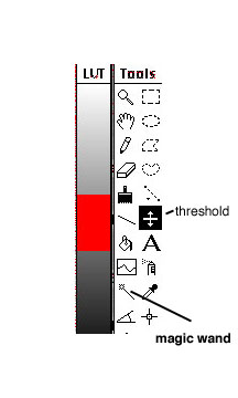
- Use the mesurement menu to measure something.
- Options changes what it measures (such as area, perimeter, etc).
- Show results gives a window of the measurements you have made, save the
measurements to a text file.
-
Using the Netware Login
- double click on the Jefferson Icon on the desktop.
- enter the appropriate options (you want the student and year context correct)
- when you're in, you can simply move files from folder to folder
- DON"T FORGET TO LOG OUT by clicking on the tree in the upper right corner.
Your homework is....
- Determine the percentage area in Rockbridge county that is officially "urban"
(indicated on the 1:50,000 map of the county) using the digitizing tablet.
- You will do this by digitize the area of towns as shown on the map and then
the area of the whole county. Use UTM coordinates on map to calibrate
it.
- Email me a table that shows the measured areas and calculated percentage.
- Estimate the average diameter of the phenocrysts in the field photo entitled
"orbicular granite bw.tif" doing heads-up digitizing using the program
"ImageNoFPU 1.49.5" on the same mac that the digitizer is connected
to.
- Estimate the percentage of phenocrysts and groundmass in the field photo.
- Email me a table that shows the measurements, calculated diameters and
calculated percentages.