
Figure 1. Sections you are to make (enlarge this on screen to see it clearly, just putting this all in one place for you).
Your task is to do a regional lithostratigraphic log correlation of the well log data from the North Slope in the National Petroleum Reserve of Alaska (NPRA) and report the results. You are to work in teams of two. Ideally one of you would be more experienced (upperclassmen, had sed/strat or geophysics). Unless someone wants to work alone, there will have to be one group of three. If you are in a group of three for this assignment, you are not to be in another assignment in the class. Each team member is to be fully engaged in the correlations. It works best if you sit together to do this. You are not to copy any other team's work, nor even look at their project, without their explicit permission. You should pledge all work.
Project is Due Mon. Oct. 6.
1. A Kingdom project entitled " North_Slope - Well Log Correlation Exercise 2025" with all of the logs for the wells loaded, as well as selected formation tops. These tops you are to consider as accurate and act as a seed for your own well log interpretation.
2. The Minerals Management Service (MMS) OCS Report 91-0076. This report explains the criteria for the correlation of logs on the northern part of the North Slope and near offshore Beaufort. It does not cover all of the NPRA, but is accurate for the northern part. In fact, a couple of the wells in your area are shown correlated in this report. For these wells you may directly copy the interpretation of the formation tops. Note, the correlations will change as you move south, so do not assume that all relationships they saw in the north, hold for all of your area. Furthermore, this a very old report and thus has some antiquated ideas.
3. A good summary paper of the geology of Arctic Alaska by an Alaska geology legend, Ken Bird. This is a big-picture view of Arctic Alaska but is quite good. You can consider your log correlation to be your evidence for supporting, refuting, or adding to this review paper. At the very least it provides context for your interpretation, and it gives a good overview of the stratigraphy.
4. A fairly detailed strat column for the NPRA from USGS Fact Sheet 045-02.
5. Two geologic maps as tif files. You should import these into your project as culture. These will tell you what formations are at the surface and thus what formation the well encountered initially. The one titled “Geo Map Alaska Arctic.tif” is from Wilson et al. (2015). The one titled “Geo_NPRA_Geology.tif” is from Mayfield et al. (1988).
Below are the citations for the geologic maps. You will want to format any of the other references in a similar format.
Mayfield, C. F.., Tailleur, I. L., and Kirschner, C. E., 1988, Bedrock geologic map of the National Petroleum Reserve in Alaska, in Gryc, G. ed., Geology and Exploration of the National Petroleum Reserve in Alaska, 1974 to 1982: U.S. Geological Survey Professional Paper 1399, p. 187–190.
Wilson, F.H., Hults, C.P., Mull, C.G, and Karl, S.M, comps., 2015, Geologic map of Alaska: U.S. Geological Survey Scientific Investigations Map 3340, pamphlet 197 p., 2 sheets, scale 1:1,584,000, http://dx.doi.org/10.3133/sim3340.
You should not need to use any other sources on the geology in the area in order to complete the assignment, but you can if you like. I would discourage this, as the reason for the assignment is for you to learn how to do regional log correlation and not regurgitate stuff from a literature search. The MMS report is enough to get you going. If you do choose to use any other sources, such as published articles or the internet, you must cite clearly what you used. Regardless, you should cite the MMS report, the Bird paper, the USGS fact sheet, and the geologic maps as you are to use these. You are absolutely not to use any other Kingdom projects, either research or former class projects, or look at another former class presentation. This absolutely falls under the honor code.
The wells that make up the correlation are:
Peard 1, Kugrua 1, South Meade 1, Ikpikpuk 1, North Inigok 1, Inigok 1, Seabee 1, North Kalikpik 1, East Teshekpuk 1, Cape Halkett 1, J W Dalton 1, Drew Point 1, East Simpson 2, Kuyanak 1, West Dease 1, Tulageak 1, South Barrow 17, Walakpa 1, Walakpa 2.
You can and should look at other wells in the project too, but you do not need to completely correlate these. The number one mistake students have made in the past is to not look at any of these other wells. They are really informative. So, you really might want to correlate through some of these other wells to help understand the correlations in your sections.
The 5 correlation sections you are to make are shown in Figure 1 (enlarge this pdf on the computer to see them).
The lithostratigraphic formation tops you are to correlate are the following:
Nanushuk Group, Torok Fm., Pebble Shale Unit, Kingak Shale, Shublik Fm.
Note in the MMS report the equivalent of the Pebble Shale is the HRZ, and of the Kingak is basically the LCU.
The Basement is given to you (no interpretation necessary), and should be included in your sections if you think it was penetrated in wells.
You might want to correlate other formation tops, Lisburne Group is probably the most useful, but I wouldn't spend much time doing that. Only do that if it helps you to understand the existing formation tops. You can include Lisburne in your sections, but there is absolutely no requirement to do so.
As mentioned above, there are lots more wells in the project. Feel free to turn these on and even to use them if you wish to help you with your regional correlation, but make sure you that in your presentation you still have at least have final displays of the 5 sections required. You can include supplemental sections or simply refer to other well picks in the narrative to support your displayed interpretation of the five sections.
Do not change the colors of the formations from what are set for you.
Note, this is a regional log correlation spanning several geologic periods. This is not a reservoir-level interpretation. So, you are looking at packages (100s to 1000s of ft) of distinctive log character, not one kick in one direction or the other. So, you really want to spend time on what you see as a suite of changes in log character that define a formation or group. There will be variations from well to well, just like there would be variations in an outcrop from place to place if it covered several hundred meters and was separated by 10’s of km.
The deliverables are:
1. An interpreted Kingdom project of the formation tops in the area (just tell me where it is on the Q or P servers).
2. A PowerPoint presentation emailed to me and printed out that addresses (explains, summarizes, synthesizes) the regional highs and lows, the spatial and temporal distribution of unconformities and related regional timing of uplifts based on YOUR well log correlations. You will want to use annotated figures from your Kingdom project. Furthermore, you should explain the criteria you used to correlate the logs. This should be a restating of the MMS report criteria (cited, of course), but more importantly the criteria you have come up with. This is an important part of the assignment as it is your take on what you see.
At the very least the powerpoint should have the 5 stratigraphic correlation cross sections in depth with equal spacing (a correlation section) through the wells shown below in Figure 1, along with contour maps of the each of the formation tops, and isopachs (in depth) between each of the tops. At least one map should show where all the section lines are, labeled of course. Additional figures with expanded parts of the logs to show details of correlations are probably warranted.
The powerpoint should follow the guide for technical presentations in the class folder. I will be really picky about things like missing annotations, text you can’t read, etc. A fair part of this assignment is for you to learn the way I think you should make a technical presentation.
Note, this is a regional correlation, so the purpose of the maps is only for regional trends (regional highs, regional lows, regional timing, and regional sedimentation or lack thereof). They are not in any way to be showing traps, closures, spills, individual faults, etc. Furthermore, the mapped region should not extend too far beyond the well control. Grid inside a convex hull polygon---you can digitize this. What I mean is surround the wells and do not use a default rectangle that extends off into uncontrolled areas, or where you interpret there is no formation present. But do not make the polygons too tight or you will not really be showing the areal extent of a formation (it is not as if the wells by default penetrated the limits of a formation). The additional wells, with picks might be very handy here. Come talk to me if this isn’t clear.
If you don’t interpret a top to exist in a well, then it better to not show it on the map as being present or having any thickness. In fact, if you interpret that a formation is missing from a well, you are probably interpreting an unconformity, so you should depict that on the map by the limit of formation’s extent between a well that does and does not have the formation. You can use a polygon limit for this. Be careful about using the default grid spacing. It is often good, but think about the spacing of your data, and make maps that reflect your control, and/or make sure to smooth a lot. If on your map you can clearly see where there is control and where not on a grid, then you have gridding artifacts (usually bull’s-eyes with well picks and chain of beads with 2D seismic picks). This may be mitigated with significant smoothing, but you might also consider changing your grid spacing.
As a bonus, if you see any intervals that look like pay, then mentioning them with an annotated figure wouldn't be a bad thing to do.
Steps in completing the assignment.
Start by copying all of the above data to your directory on the P or Q drive.
Open the Kingdom project file entitled "North Slope.tks".
Rename the user "student" to your initials (Project->Author Management), and perhaps make another author, or copy this one. That way both of you can make picks and you can compare.
Set your default scales and whatnot for sections and maps. Note there is a culture file that shows the NPRA outline.
Import the two geologic maps as culture files.
Figure out what wells have what logs, formation tops etc.
Set up your log displays as shown in Figure 2 with the curve tracks shown.
Make the arbitrary sections above.
Correlate your logs, identifying the required formation tops. HAVE THIS COMPLETED BY NEXT LAB. Come with questions, problems, issues with your correlations.
Make grids, then contour maps of the formation tops. Note you should use polygons to limit the area that is gridded.
Visualize in VuPak if you want. Not necessary, but maybe useful. I can show you how to do this.
Make isopachs (Tools->Calculators->Math on Two Maps).
Make your PowerPoint.
Smile, you are on your way to becoming a real petroleum geologist.
Figure 1. Sections you are to make (enlarge this on screen to see it clearly, just putting this all in one place for you).
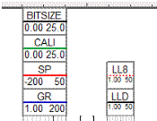
Figure 2. Curve tracks with scales you are to display on the sections.